

I had a horrible day at my real job.
So, I checked out and braved the snow… I wish it was worth it. An hour later, I was sitting at the local pub with a plate full of nachos and pint of Miller Lite… two pints of Miller Lite.
Someone had suggested on my previous post that the snow sometimes insulates the ground and keeps it from freezing. That was not the case at Pine Grove Furnace today. I headed straight for the beach, thinking that the sand would be loose… I was stabbing at it with my screwdriver for a good five minutes before I gave up. The good news is that I relieved most of my frustration.
Then, I wandered around for an hour looking for big trees with no luck. There were no big trees… so, given the frozen ground and the lack of big trees–where I usually get my best finds–I decided to pack it up and head to Mt. Holly Inn to warm up.
Since the snow started falling, I have been collecting permissions. When the spring hits, I will be busy. I’ve received permission for two mills (1809 and 1765ish), an old zoo (1950), an old iron quarry (1850ish), an old house (1850), a township pool (1920), a local cave–which was once the hideout of Lewis the Robber, and a swimming hole . On top of that, one of the guys that I detect with got permission for a property off Route 11 near Chambersburg. Any PA history buff know the significance of Route 11?
Let me tell you. Back in the 1758 during the French and Indian War, a British man named John Forbes set off to create a route through Southern Pennsylvania in order to capture a French fort near Pittsburgh. Back then, this area was largely Indian territory. (On a side note, Mary Jameson, the daughter of Irish immigrants who become the poster-child of the the French & Indian War lived in the mountains a few miles from here.)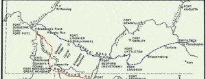
Anyway, John Forbes set out to accomplish what Edward Braddock had attempted before him a few years earlier. Instead of continuing on Braddock’s Road as George Washington–who accompanied the army–suggested, John Forbes created his own route through the mountains. Forbes Road follows Route 11 and even Route 76 in some sections.
That being said, this property in Chambersburg is kind of a big deal. There are at least three old foundations on the land that have long since been abandoned. I’m pretty excited to make the trip out there and get digging.
Now, the other guy who I detect with has permission from a local historian for a property where the confederate officers camped before setting out to shell Carlisle. The historian offered to take us through the property and show us the camp set-up. He asked that we relinquish any historical artifacts that we find, but I could live with that. I am just looking forward to the opportunity to dig on the site.
He did say that a couple guys had gone through with their detectors once before, but the historian thought they were sloppy and missed a lot–they didn’t even detect near the officer camp or check out the hand-dug well! Whatever, their loss.
So this has been my winter thus far… I will have no shortage of hunts come Spring.
Happy Hunting!